Last verified 28 October 2026. This is an independent record, not a government site, and nothing here is legal, medical, or real-estate advice.
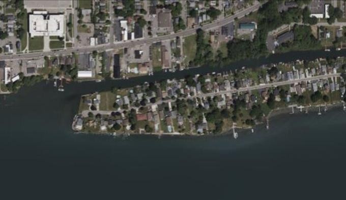
Cayuga Island is a mostly residential island of about 140 acres in the upper Niagara River. It sits in the LaSalle section of Niagara Falls, New York, with the Niagara River to the south and the Little River separating it from the mainland to the north (background). Since late 2025, the western end of Cayuga Island has been the subject of a state investigation into contamination in the fill the land was built on.
This post summarizes what the agencies have confirmed, what has been reported, and what is still unknown. Every fact links to its source. We separate three kinds of source: agency records (Primary), named journalism (Reporting), and individual opinion (Commentary). For the full dated record, see the Cayuga Island timeline.
How the Cayuga Island investigation started
In 2025, a contractor working ahead of a new water main drilled soil borings in the West Rivershore Drive right-of-way and noticed a chemical odor. The samples sent to the New York State Department of Environmental Conservation (DEC) showed “elevated levels of several contaminants related to industrial material.” DEC then took its own samples from the same right-of-way. The results, received in early December 2025, were “consistent with historical data” and showed “exceedances of DEC screening levels in residential settings for several contaminants” (Primary: DEC, September 2026 Site Investigation Update).
DEC gives three reasons for acting now: the new data, the historic use of fill in creating the island, and “revised requirements for addressing contamination” (DEC fact sheet, 1 Sep 2026). In February 2026, DEC and the New York State Department of Health (DOH) began contacting property owners on the westernmost tip (DEC, February 2026 fact sheet).
Why the west end of Cayuga Island is different ground
Part of the island is man-made. DEC says the western end “was extended in the early 1900s and again between 1958 and 1962 using fill that included industrial material” (DEC, 1 Sep 2026). A 1984 report prepared for DEC describes the western tip as extended 250 yards into the river before 1930 and widened between 1958 and 1962 (Primary: 1984 Phase I Summary Report).
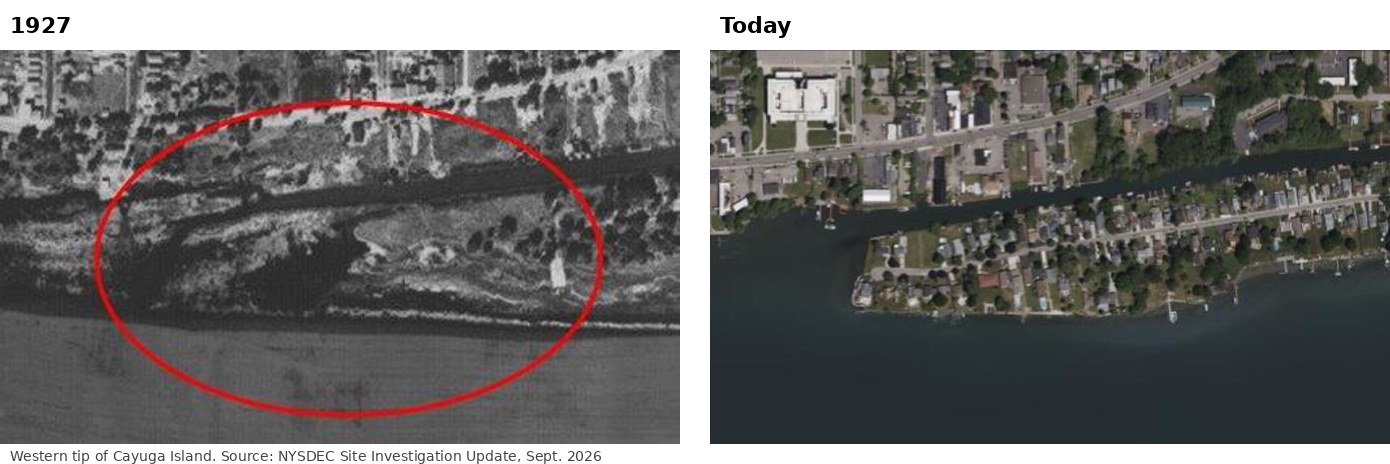
The western tip in 1927 and today. Source: NYSDEC Site Investigation Update, Sept. 2026.
That 1984 report also states that “NYSDEC files indicate” five companies “as having supplied fill.” It is important to read that carefully. A company being listed as a fill supplier in old files is not a finding that it contaminated anything, and DEC has not named a responsible party in any of its 2026 documents. In September 2026, a DEC official told The Buffalo News that agency attorneys are “still looking into and trying to seek information from who we consider potential responsible parties” (Reporting: Buffalo News via Chemical Processing, 25 Sep 2026). For more, see how the land was made.
What has been found on Cayuga Island
Contaminants named in the record
- DEC’s 2026 fact sheets name mercury, pesticides, and “other contaminants.”
- The state’s remediation database for site 932008 currently lists alpha-BHC, beta-BHC (pesticide compounds), mercury, trichloroethene (TCE), cis-1,2-dichloroethene, and 1,1-dichloroethene (Primary: NY Open Data, program 932008).
- DEC’s 1993 supplemental assessment concluded that “elevated levels of lead, mercury, pesticides and PCBs were detected in the western area” (Primary: 1993 PSA Supplemental).
What DEC confirmed in September 2026
DEC’s most recent fact sheet says sampling at participating properties “confirmed some impacts to indoor air and soil.” It also says property-specific plans “to address any contamination needing mitigation are underway” (DEC, 1 Sep 2026).
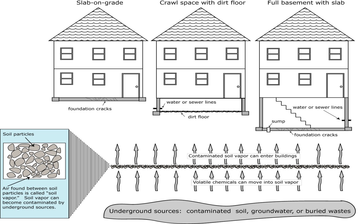
How soil vapor intrusion works. Diagram: NYSDEC Site Investigation Update, Sept. 2026.
According to The Buffalo News, 7 of the 22 property owners first contacted had granted access. Of those 7, one home had unhealthy indoor air, and DEC installed a system to vent it. All seven had soil that DEC considered unsafe and “will have the top 2 feet of soil removed and replaced,” with the work expected in 2027. DEC also reported testing river sediment around the island and not finding the same chemicals (Reporting: Buffalo News, 25 Sep 2026).
Why we don’t publish numbers
DEC gave sampling results “directly to the property owners” and has not published per-property concentrations. The Buffalo News has reported figures from DEC data shared with the paper, and you can read them at the link above. This record does not repeat any concentration DEC has not published itself. We explain that policy on our About page, and the What was found page explains what a “screening level exceedance” does and does not mean.
The second phase: the investigation is moving east
DEC and DOH “are beginning a second phase of investigations.” Offers will be extended to “certain additional properties along West Rivershore Drive” to find the extent of the impacts (DEC, 1 Sep 2026). The Buffalo News reported that on 8 September 2026 DEC contacted 12 more owners just east of the first 22, and that four agreed to testing. DEC’s Region 9 interim director, Chad Staniszewski, said: “we have not hit clean (soil) yet, as far east as we were able to sample” (Buffalo News, 25 Sep 2026).
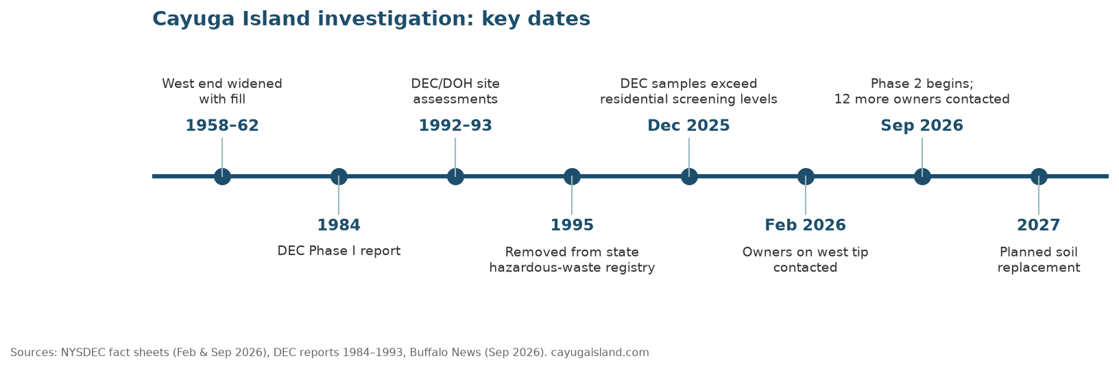
Key dates in the Cayuga Island investigation. Sources: NYSDEC, Buffalo News.
Is Cayuga Island a Superfund site?
No. Cayuga Island (DEC site 932008) is Class P, “Potential.” That means it is under investigation to decide whether it belongs on the state Registry of Inactive Hazardous Waste Disposal Sites (DEC site classifications). DEC says the site was delisted from that Registry in 1995 (DEC, 1 Sep 2026). The federal EPA lists the location as “Cayuga Island LF” and has determined it does not qualify for the National Priorities List on existing information (EPA site profile).
Love Canal, a federal Superfund site (EPA), is nearby in LaSalle, which is why the two are often compared. Being close to Love Canal does not change Cayuga Island’s classification.
The 28-year gap
This is not the first time the state has looked at this ground. In 1992 and 1993, DEC and DOH assessed the western end. They found “sporadic contamination of mercury, pesticides, and other contaminants in surface and subsurface soils,” sent each owner a notice of the levels found, and told owners to contact DEC or DOH before doing any ground-intrusive work (DEC, 1 Sep 2026). DEC told the Niagara Gazette that its last completed investigation before 2025 was in 1995, when it designated the western end Class N, “no further action” (Reporting: Niagara Gazette, June 2026, reposted).
People on the record disagree about what this means:
- Environmental attorney Christen Civiletto called the delay “alarming” and “inexcusable” (same article).
- Assemblyman Angelo Morinello urged residents to cooperate with testing (Reporting: WGRZ, 17 Jun 2026).
- Island property owner J. Gary DiLaura disputes that any danger exists (same WGRZ report and his own blog, 10 Oct 2026, Commentary).
We report these positions and do not take sides. The only agency finding on the record is DEC’s statement that impacts to indoor air and soil were confirmed at participating properties.
What Cayuga Island residents can do now
- Ask for testing, even if you said no before. DEC says it will accommodate owners in the investigation area who were previously offered sampling. Contact Sarah Whiteway, DEC Public Participation Specialist, at sarah.whiteway@dec.ny.gov or (716) 851-7192 (number as printed in the fact sheet).
- Send health questions to DOH. The Bureau of Environmental Exposure Investigation can be reached at beei@health.ny.gov or (518) 486-7016. Its soil vapor intrusion guidance is a good primer.
- Call before you dig. The 1990s instruction to contact DEC or DOH before ground-intrusive work was never withdrawn.
- Know what it costs. DEC says investigation, any mitigation, cleanup, and restoration “will be completed at no cost to the homeowner.”
Our For residents page walks through each step, and every source document is linked in the document library.
Frequently asked questions about Cayuga Island
Where is Cayuga Island?
It is in the upper Niagara River in the LaSalle neighborhood of Niagara Falls, NY. The investigation is focused on the western end, along West Rivershore Drive.
What contaminants were found on Cayuga Island?
DEC records name mercury, BHC pesticide compounds, TCE and related chlorinated solvents, and, in 1993 assessments, lead and PCBs. DEC has not published current per-property concentrations.
Is the whole island contaminated?
Nobody has said so. The investigation covers the filled western end, and the second phase exists to find out how far the fill extends.
Who is paying for testing and cleanup?
DEC states that all investigation, mitigation, cleanup, and restoration work is at no cost to homeowners.
Who is responsible for the contamination?
DEC has not named a responsible party. Historical DEC-file references to fill suppliers are not findings of liability.
Is there a lawsuit about Cayuga Island?
We have found no lawsuit concerning Cayuga Island in any source we index. No court docket was searched.
How do I stay updated?
Sign up for email updates on the For residents page, or check this blog. New DEC documents usually appear in the site 932008 folder before any announcement.
Corrections: if anything here is wrong, tell us and we will log the fix publicly on our About and corrections page.
